Image credit: David Seibert
Year Erected: 1956
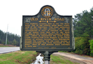
Marker Text: The highway crossing here is the Old River Road, one of the earliest colonial routes west of the Ogeechee River. The colony opened this portion of the old thoroughfare in 1777. It followed the course of a Native American trail that led to the Rock Landing on the Oconee River, south of modern-day Milledgeville, intersecting with the Lower Creek Trading Path that ran from Augusta to the Muscogee (Creek) territory in western Georgia. The River Road became a main thoroughfare of the state after Milledgeville became the state capital, connecting the city to Savannah. Parts of the route are still in use today.
Re-erected in 2024 by the Georgia Historical Society
Tips for Finding This Marker: On U.S. 80 near U.S. 280, on the right when traveling south in Ellabell.
Explore this marker and more through the Georgia Historical Society's interactive database.